Of course All Saints, Northampton is not ‘lost’, it is there in plain sight and for 300 years has been an iconic feature of the town. This building, however, is not the first church on this site. The original All Saints (or All Hallows, as it was sometimes known) was tragically damaged by a fire in September 1675. Within just four years the structure we see today emerged from the ruins. This article explores what we know of the previous building and how it might have looked had it survived.
The first All Saints: before the fire of 1675
There are few illustrations of the building and they tell an inconsistent story of the external appearance of the building. Contemporary descriptions add some detail and give an overall impression of the building.
One of the earliest depictions of the church is on John Speede’s plan of the town published in 1610.

In 1669 Cosmo III, Grand Duke of Tuscany travelled around England1
. An unknown artist captured a view of the town at the time. The representation of All Saints shows a tall building, the nave and chancel higher than Holy Sepulchre and St Giles but viewed from the south the differing styles of the nave on the left and the chancel on the right are similar to the view in Speede’s plan of the town. There is some doubt about how accurate the tower is given its open structure is more of an Italianate style and probably tells more about the artist.

A redrawing and enlargement by Mr C A Markham for Serjeanton’s 1901 definitive history of the church2 is helpful for clarification. A close comparison of the sketch in Speede’s map (1610) and the Italian artist’s depiction (1669) shows some correlation between the west end of the nave and the two-storey transept south of the tower. It is also clear that the nave extended west-wards to the same extent that the chancel was to the east.


Henry Lee who was Town Clerk at the time of the fire in 1675, describes both the old and new churches:
“This new church of All Hallows was built upon ye foundacons of ye old chancell wch was very large, with great stalls and large desks before ’em on ye north and south sides of ye chancell and on ye west side very gentile pews wth Desks before them to lean upon. The whole was large enough to receive ye Parliament called by King Richd ye 2d. And it was held in ye said chancell. When this church was built there was noe ground added, only 10 foot taken out of ye churchyard on ye east to make ye present chancell longer which formerly was a Library and too small for ye use its now put unto.
“Many have sayd yt ye old church was as large as some cathedralls; it was larger than this, being wider and longer. The west wall of ye churchyard over against Alderman Collins’ house and Mr. Fowler’s house, is built upon ye foundation of ye old church where in ye middle were stately gates at ye entrance, and a very high and large window. There were 3 iles in ye church and in ye [1534-35] 26 year of the Reign of King Henry the 8th there, Nicholas Rands, Mayor, ye middle roof of All hallows church was made and raised very high and loughty. On ye middle of ye church wall on ye church was a chappell built by Mr. Neale who had been Mayor, very finely built wth white stone. There was a south porch very great and large, and over it was a large roome in wch ye spiritual court was held.
Rebuilding
The present building was constructed on part of the foundations of the original. Only fragments of that first building remain, although they do provide a starting point in establishing the overall size. The ‘modern’ tower stands on the foundations of the original tower thereby giving its size and precise location. Further, the medieval crypt is under the east end of the present chancel, marking the eastern extremity of the medieval building.
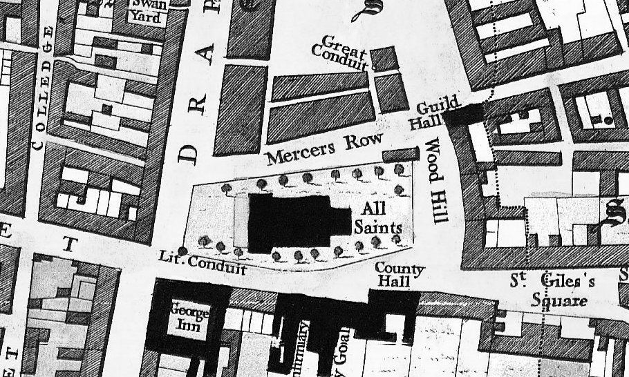
A useful plan was produced in 1901 which shows the relation of these features to the present building.

At the time of rebuilding in 1679/80, the area previously occupied by the nave was taken up by the portico and the graveyard enclosed by a wall and gates. From the time of rebuilding to the present day the area around the building, particularly the west churchyard, has been progressively given up to widening the Drapery.
Referring back to Speed’s plan, it can be seen that the south end of the Drapery was narrow compared to the present day. Moreover, what is now known as Jeyes Jetty (but formerly College Yard) led from All Saints through to College Lane (Street).
The next useful plan we have of the area is Noble and Butlin’s map of 1747. This clearly shows the extent of the churchyard and the position of the building within it. It confirms the narrow road at the south end of the Drapery. The map also introduces the ‘Little Conduit’ that stood at the south-west corner of the churchyard. This conduit is believed to have been erected in the 13th century when the town was extended. It was supplied from a spring in the grounds of present-day St Andrew’s Hospital. The conduit is a useful boundary marker. It suffered some damage in a storm in 1815 but was removed in 1831 as part of a scheme to rebuild the wall and railings around the churchyard.
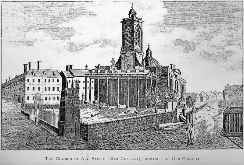
The next illustration shows the west end of All Saints in the late 18th century before these works commenced and around the time of Noble and Butlin’s map. It indicates that the churchyard itself was in a poorly maintained state but that there was space for a row of trees along the south side of the building.
Retreat
In 1871, the Northampton Improvement Commissioners, with a view to widening the lower end of the Drapery, obtained an Act of Parliament authorising them to cut off and secularise a portion of the west end of the churchyard of All Saints. The work was carried out in the autumn of that year. The 1885 map below clearly indicates the reduction in the churchyard compared to the 1747 map.

What might have been
Had those events of September 1675 not tragically destroyed the first All Saints, we could today be looking at a church much larger than its replacement, in fact about 180 feet (55m) long and 55 feet (17m) wide. How this would have impacted on the current street-scene and competing pressures for space is interesting to consider.

- Magalotti, Travels of Cosmo the Third, Grand Duke of Tuscany, through England during the Reign of King Charles the Second (1669). Tr. from the Italian Manuscript in the Laurentian Library at Florence. To Which Is Prefixed, a Memoir of His Life, 244–45.
- Serjeantson, Robert Meyricke. A History of the Church of All Saints, Northampton. Northampton, W. Mark, 1901.
© Copyright : Graham Ward. All rights reserved.